United Federal Britain - Local Government
This post follows on from A United Federal Britain. Having changed all of the borders it would make sense to tidy up all of the counties. As mentioned in Legibility and Democracy, the current state of the UK's administrative areas is a mess. Some areas ar
This post follows on from A United Federal Britain.
Having changed all of the borders it would make sense to tidy up all of the counties. As mentioned in Legibility and Democracy, the current state of the UK's administrative areas is a mess. Some areas are two-tier counties that have a county council as well as multiple district councils within them, while other counties are purely ceremonial and have no government function, having been split into rural and urban unitary authorities. To make matters even more confusing, some counties are two-tier, but with some districts carved out of the original ceremonial county to be unitary authorities not governed by the county council itself (e.g. Nottingham and Nottinghamshire).
In the following map, I have split each state into unitary authorities, so that there is a single consistent level of government below the state government. In a similar manner to with the states themselves, I have tried to separate urban and rural areas into separate authorities, so that local government can also avoid the pitfalls of having to cater to constituents whose requirements are too much at odds with each other.
Clearly the states themselves should have the powers to adjust their internal divisions as they see fit, rather than being handed them by the federal government, but if we are creating the states from scratch, we can at least give them sensible divisions to start with. In fact, given the issues that the US has with local government, it is apparent that managing the borders of local administrative areas cannot be permanently devolved below the level of the state. If local governments (below state level) are given some degree of control over their own borders, there needs to be a way for the state government to step in when populations change too much or their existing layouts become pathological. A similar kind of approach to the proposal for adjusting states within a federation may work for this.
These administrative divisions are referred to as "cities" for urban areas of rural states (coloured cyan), "counties" for rural areas of rural states (coloured green) and "boroughs" for areas of metropolitan states (coloured blue):
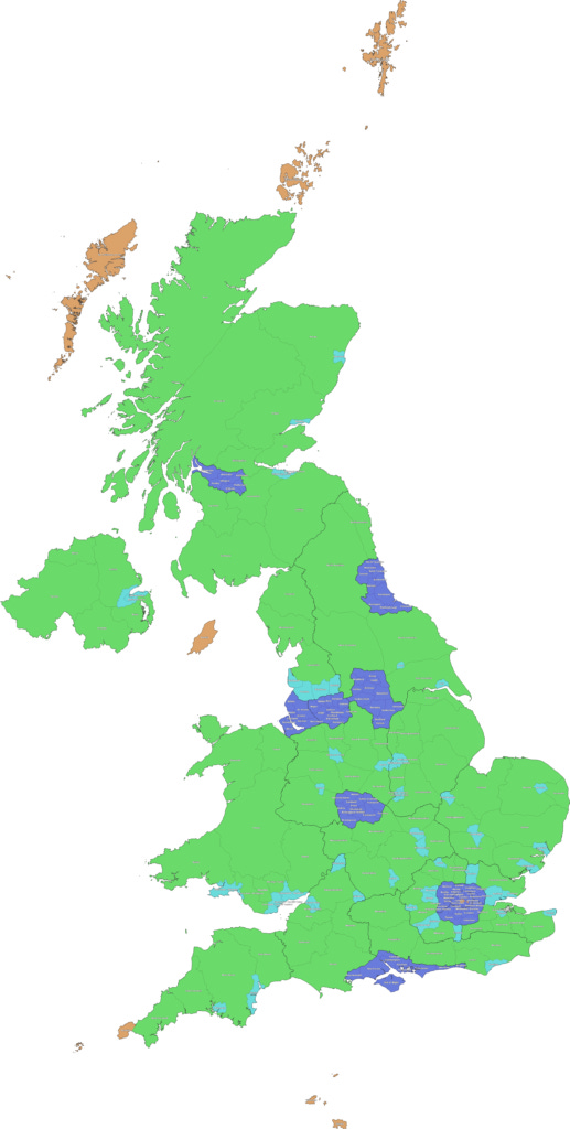
These 256 divisions consist of 85 Counties, 50 Cities, 109 Boroughs and 12 special districts. Aside from the special districts that I will mention briefly below, all 244 counties, cities and boroughs have a population between 125,000 and 400,000. Population information can be seen on the map below by clicking the relevant area.
This is in stark contrast with the current situation in which there are 404 principal local authorities in the UK - 25 county councils, 188 district councils, 56 unitary authorities, 36 metropolitan boroughs, 32 London boroughs, 32 council areas in Scotland, 22 principal areas in Wales and 11 local government districts in Northern Ireland, as well as the sui generis Council of the Isles of Scilly and the City of London Corporation. The unitary authorities alone vary in size from Cornwall with 570,000 people to Rutland with 40,000, whilst the largest metropolitan borough is Birmingham with 1,100,000 people and the Isles of Scilly have a population of just over 2,000.
Brief side-note on "Special Districts":
The special districts are smaller in population (21,000 to 100,000) and are coloured orange on the map.
They consist of central London (London, Westminster, Bloomsbury, Southwark, Docklands), Northern Scotland (Orkney, Shetland and the Outer Hebrides), Penwith (including the Isles of Scilly), Jersey, Guernsey and the Isle of Mann.
These 12 exceptions are due to their unique nature, for which it is probably beneficial for them to have their own local governments despite their small size.
The 3 sets of Scottish islands each need their own local councils due to how far they are away from each other, despite their small populations.
Penwith includes the unique Isles of Scilly whose requirements could be overlooked if it were combined into an area that dwarfed them too much. On their own, the Isles of Scilly make up around 0.1% of the population of Kernow, so keeping them as a district by themselves would both involve the Kernow state government having to deal with a tiny authority which would be quite inefficient, as well as having the local authority itself being comparatively large with respect to the population it serves. This district is then aimed at finding a middle ground between being so large that the Isles unusual requirements are overlooked, and so small that the authority becomes a burden on both the citizens and the state government.
Central London's 5 special districts have been kept small because of the sheer number of companies registered there. Just as addressing people's concerns becomes more difficult as the number of people increases, the same is true of companies. This also avoids a single local authority having too much influence over the large economy of central London.
The crown dependencies of Jersey, Guernsey and the Isle of Mann are exceptions because they currently have independent governments, and any attempt to combine them properly into a United Federal Britain would likely require an element of independent government to continue.
I have placed the Isle of Mann into Rheged and the channel islands into Solent because they are all far too small to be states in their own right, but if their integration could be achieved, they would likely retain more autonomy within their respective states than an ordinary district.
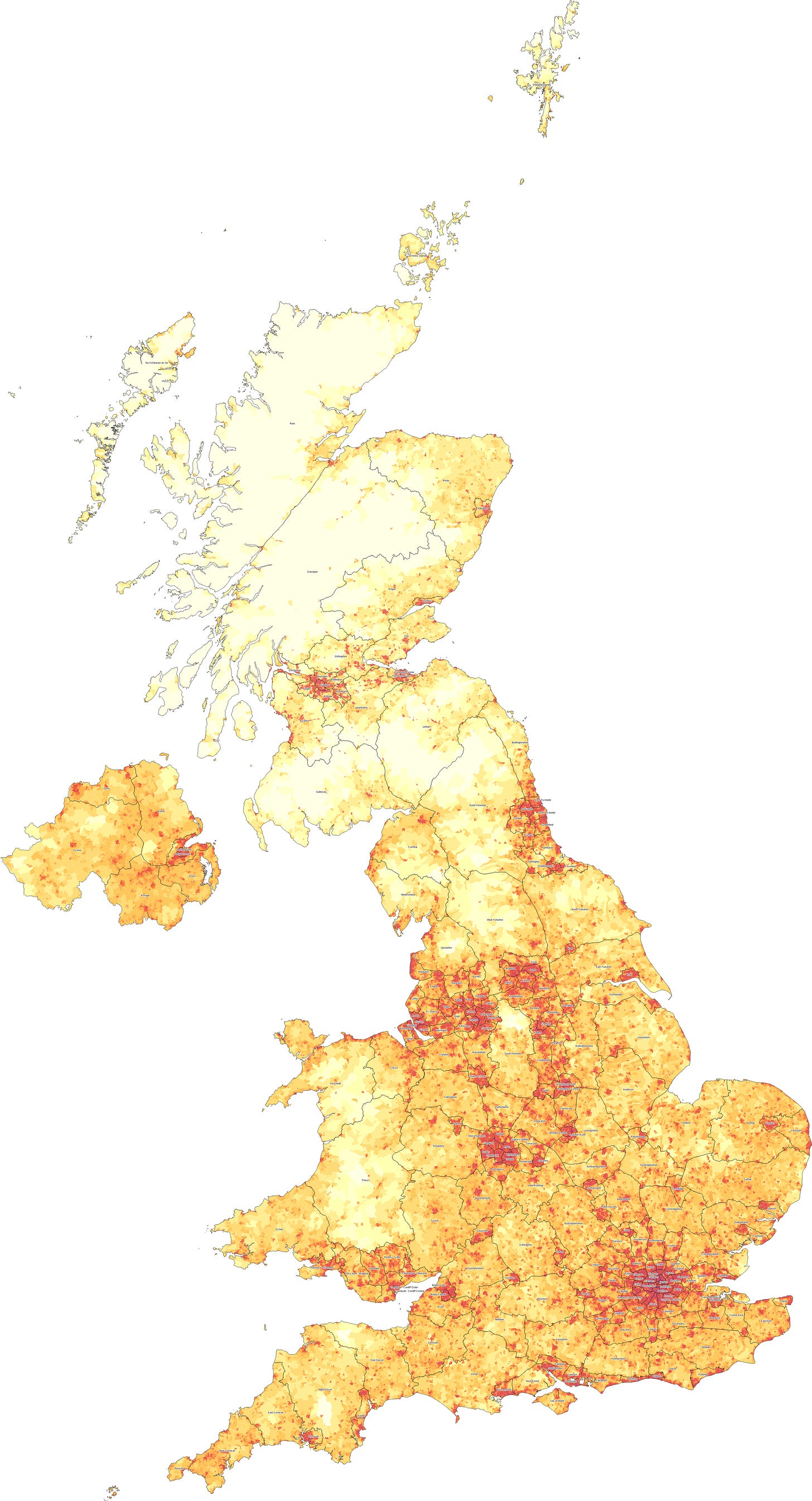
With these administrative divisions (listed in full at the bottom), it might look like I have used a cut-off of 750 people per square kilometre between something being a county and being a city. It is not just an arbitrary cut-off though. The least dense cities (Blackburn, Cambridge and Newport) still have city-like characters, with a main centre, some satellite towns and some less dense suburbs or countryside around them. This is in contrast to the most dense counties (Windsor and Hertfordshire) which have a much more even distribution of towns, giving a more decentralised character. With this approach in mind, I have tried to adjust the borders of the cities and counties to generate a sensible structure with cities and counties having both different characters and being on different sides of a population density cut-off.
I have uploaded the map above to Google Maps, allowing it to be overlaid on top of a zoomable map of the UK:
Cities and Counties
The UK currently does not have a population based metric for determining whether something is a city, preferring instead to confer city status by virtue of having a cathedral, or manually on an ad-hoc basis. Accordingly, there are several tiny cities on this list that no longer make the cut (e.g. Truro, Bangor and Ely), and several cities that I outline that were not on the list (e.g. Telford, Luton and Milton Keynes). It is important to note however that some of the "official cities" on the list linked above have extremely generous borders, that include a large amount of countryside. The actual urban areas of Chelmsford, Canterbury and Lancaster are much smaller than their officially designated city limits, so they have a significantly lower population. This means that it makes sense to combine them with their surrounding area to make a sensible sized administrative area, but that this would be a county rather than a city.
In fact, a much better sign of whether a settlement is worthy of being considered a city is actually whether it has been split from its county, as a unitary authority. All of the urban unitary authorities that currently exist in England have made it as cities under this plan - Blackburn, Blackpool, Bristol, Derby, Hull, Leicester, Luton, Medway (as Rochester), Milton Keynes, Nottinham, Oxford, Peterborough, Plymouth, Reading, Slough, Southend, Stoke, Swindon, Telford, Thurrock (as Basildon), Torquay (as Exeter) and York.
Aside from these, the plan designates other cities in England that weren't already unitary authorities - Burnley, Cambridge, Colchester (inc. Clacton), Crawley, Farnborough (inc. Aldershot), Gloucester (inc. Cheltenham), Guildford (inc. Woking), Harlow (inc. Bishop's Stortford), Hastings (inc. Eastbourne), Ipswich (inc. Felixtowe), Northampton, Norwich, Preston (inc. Chorley), Thanet (consisting of Margate and Ramsgate) and Wycombe (inc. Beaconsfield). Many of the cities in this list are polycentric, having more than one fairly densely populated city centre, but they have a sufficiently high population of sufficiently high density to be qualitatively different to their surrounding counties.
The differences between cities and counties are apparent when the borders are overlaid on a map of population density, similar to the one in the Final Proposal section of the previous post (this one is worth clicking on, to zoom in and see the detail):
London
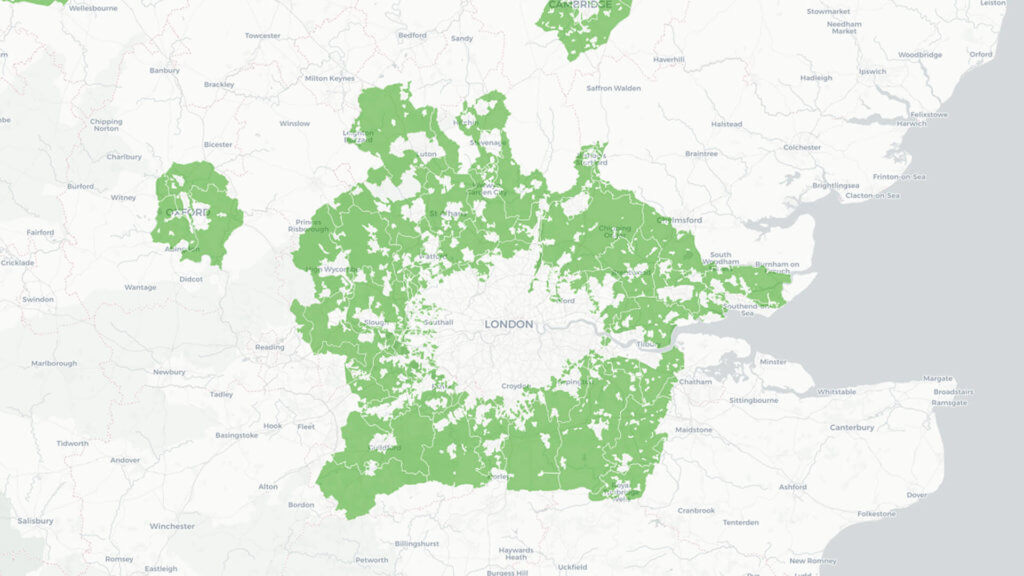
Surrounding London (in the states of Surrey and Essex) are several of these cities, sometimes forming corridors around major routes into London. These are Luton, Wycombe, Slough, Reading, Farnborough, Guildford and Crawley in Surrey and Harlow, Basildon, Southend, Rochester and Thanet in Essex. If the states have adequate autonomy over urban development and planning, these cities could be permitted to expand within their borders. This would allow for London to grow within key access corridors, without giving way to uncontrolled urban sprawl.
These corridors around established population centres allow for the possibility of a "Green Wedge" approach to London's growing suburbs, rather than the current far more restrictive greenbelt. The greenbelt was originally instituted to protect natural spaces around cities, but is so restrictive that it now has a stifling effect on London and the many other cities it affects, attempting to freeze the growth of a city at a particular arbitrary point in time. By encouraging growth exclusively within these corridors, green space remains accessible and urban sprawl is curtailed, but people are still able to live near to where their skills are in demand.
One further thing to note about the cities in this proposal is the presence of some cities that have an "outer district". These are Bristol, Leicester, Edinburgh, Nottingham, Cardiff and Belfast. Whilst still too small to be metropolitan states, these cities are too large to be contained within a single administrative division. Combining the suburbs of a large city with the rural area surrounding it would again cause friction between the different needs of these two groups of people, so I carved out 6 "cities" that allow these populous suburbs and satellite towns to have their own local government.
An alternative to this would have been to simply take the large city in its entirety, then split it down the middle, giving a North and a South (or East and West) of each city. I decided against this, because as with London's central and more peripheral areas, the high population density at the centre of a city has unique requirements that are likely best served by having their own administration. To split large cities down the middle would deny the opportunity for centre and suburbs to each benefit from a more aligned government.
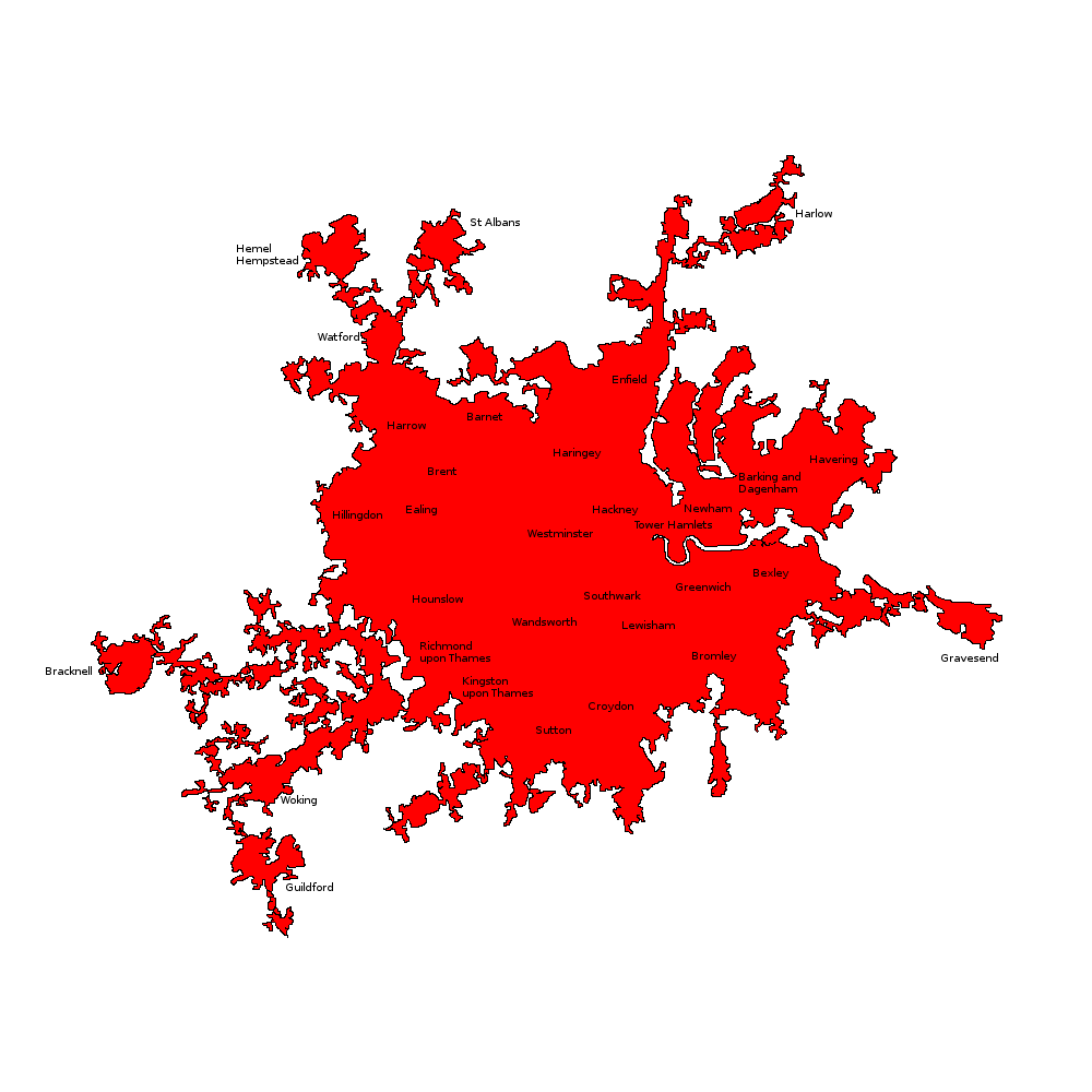
As an extreme example of this density discrepancy, I present to you a version of the population density map above, zoomed in on London. Even though Middlesex and Croydon have population densities higher than any of the other states outside London (2,911 and 2,821 people per square km respectively), the state of London itself has a population density over 3 times as high, at 9,115 people per square km:
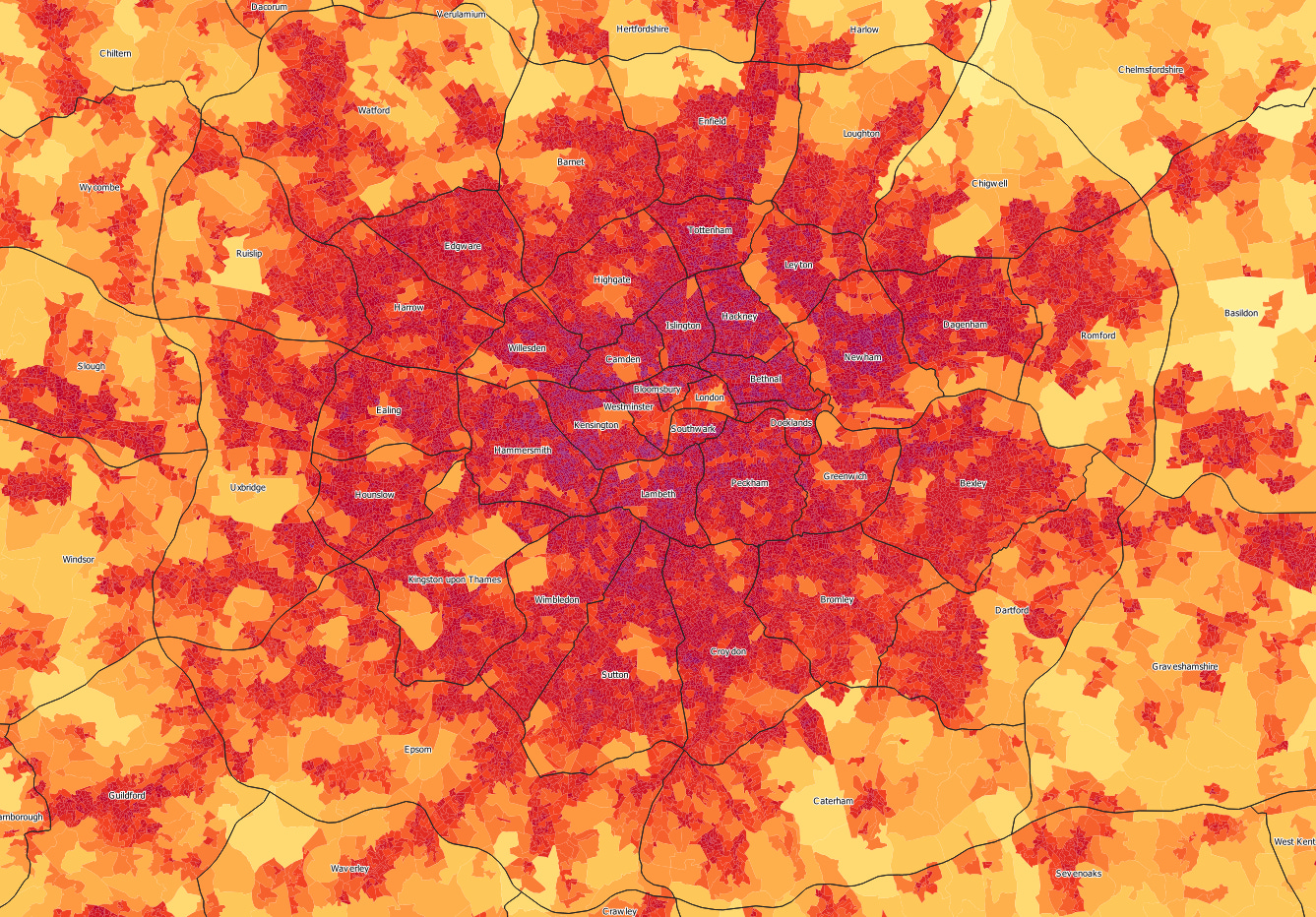
Looking at the cities outside of the metropolitan states, it is clear that the 6 cities with central and outer divisions are similar to this. The central "cities" are by far the most densely populated, ranging from 4,009 to 5,553 people per square km. This is more than double the density of their respective outer cities, and most other cities under this plan.
Borders
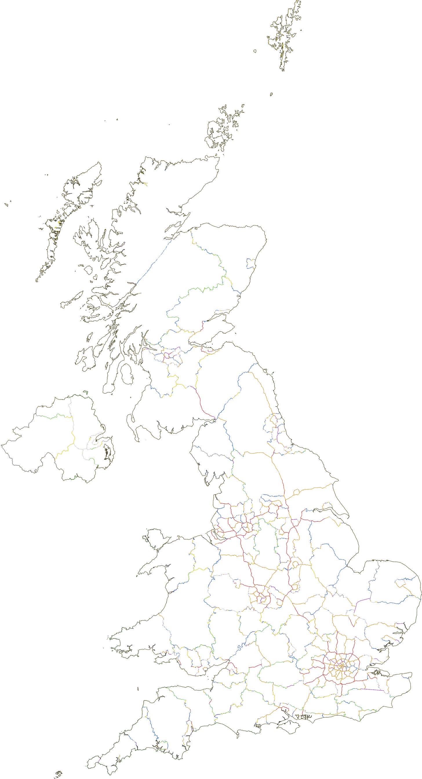
Because I mainly based these borders on geographical features, I was able to produce a map that shows which feature was used to make the border. In the map below, motorways are shown as red, A-roads as orange, railways as purple, rivers as blue, national park/AONB borders as green, existing county borders as yellow, existing district borders as dark grey and other smaller features as light grey:
Full List of Divisions
Just in case anyone wants it, below is the full list of all 256 divisions, along with the the key statistics of each. The final two columns are a possible two-letter state code and single-letter district code that provide each district with a unique identifier. (The two-letter state codes have also been chosen to avoid any clashes with US two-letter state codes, to avoid confusion between for example; Elgin, SC and Elgin, SL or Manchester, NH and Manchester MH).
These could ultimately be used to supersede postcodes, finally aligning the postal address system with the administrative geography of the country. This would avoid confusing situations such as Barking having the postcode area IG (Ilford) rather than E (East London), or Aberystwyth having the postcode area SY (Shrewsbury) rather than a Welsh postcode area.
NameTypeAreaStatePop.DensityGVA (£m)GVA/ capitaState CodeDist. CodeNorwichCity137Anglia2178651592551525315ANWIpswichCity165Anglia1994851212488524490ANIPeterboroughCity166Anglia1782651074492027597ANPColchesterCity207Anglia2079881006398019135ANLCambridgeCity252Anglia193216767754339042ANCYarmouthCounty621Anglia214599346418419499ANYDedhamshireCounty1572Anglia338569215669619777ANDHuntingdonshireCounty1219Anglia195689161487724922ANHCambridgeshireCounty1430Anglia215302151562926146ANBFenlandCounty2840Anglia326365115668520484ANFSuffolkCounty3450Anglia379935110860122639ANSNorfolkCounty3353Anglia367426110717019515ANNBirminghamBorough43Bromwich2349435447524122307BRBAstonBorough42Bromwich1866164428409121921BRASmethwickBorough67Bromwich2792934141587921051BRMCoventryBorough71Bromwich2675953756590522066BRCSandwellBorough55Bromwich1780863252321118030BRLSolihullBorough115Bromwich3579433107952526611BRHDudleyBorough126Bromwich3665132914593016180BRDWolverhamptonBorough119Bromwich3228562708571917715BRVSutton ColdfieldBorough122Bromwich2245261842506322550BRSWalsallBorough144Bromwich2367851647407317201BRWBromsgroveBorough272Bromwich244230897521921370BRGTamworthBorough291Bromwich247404850487619710BRTKenilworthBorough277Bromwich125759454356928377BRKWimbledonBorough48Croydon2769035762750427101CRWCroydonBorough65Croydon3670365640836922801CRYSuttonBorough75Croydon3892715210957724603CRSBromleyBorough61Croydon2721404443535419675CRBBexleyBorough83Croydon3619244348708119566CRXKingston upon ThamesBorough76Croydon2900243792896730919CRKDartfordBorough102Croydon1854141815456124601CRDEpsomBorough234Croydon34381514711104132114CRECaterhamBorough187Croydon141945759313022054CRCCaerdydd - Cardiff CentralCity30Cymru1375484531347225243CYCCaerdydd - Cardiff OuterCity284Cymru3516281238733820869CYOAbertawe - SwanseaCity409Cymru366113896635017346CYACasnewydd - NewportCity323Cymru255300790487019074CYNRhonddaCounty396Cymru239422605377115751CYRMerthyr TydfilCounty434Cymru256662591342913359CYMPen-y-bont - BridgendCounty841Cymru225250268405317995CYBClwydCounty1706Cymru393020230789920099CYLGwentCounty3325Cymru32766599646519731CYGDyfedCounty3842Cymru27382771430515721CYDGwyneddCounty4407Cymru30685370502716383CYWPowysCounty7361Cymru20564928349316984CYPHullCity107Deira3118782917606419445DRHYorkCity62Deira1528932447374624499DRYBedlingtonshireCounty1345Deira218771163349015951DRBEast YorkshireCounty2756Deira361392131684118930DRENorth YorkshireCounty4490Deira36447981781121430DRNWest YorkshireCounty4726Deira35979876815222658DRWNorth PenninesCounty7041Deira19647728334117002DRPLeedsBorough99Elmet3470413509953227466EMLSheffieldBorough53Elmet1799243376356519815EMSBradfordBorough146Elmet3854502642698418118EMBKirkleesBorough184Elmet3729082025797121375EMKHallamBorough186Elmet3591681933700319499EMHDoncasterBorough100Elmet1504621509254116889EMDHalifaxBorough135Elmet1890221401387320489EMXWakefieldBorough289Elmet282779978584420665EMWRotherhamBorough289Elmet275502952464116847EMRHuddersfieldBorough316Elmet259107819432716701EMUBarnsleyBorough313Elmet248511793385115495EMYEccupBorough386Elmet256502665638024873EMERochesterCity75Essex2423183225425517560EXRSouthendCity123Essex3055282485505516544EXSThanetCity104Essex1341861287201615021EXTBasildonCity362Essex3754091037880623457EXBHarlowCity301Essex269563896642923851EXHGraveshamshireCounty428Essex220980516459420787EXGWest KentCounty391Essex187593480454024204EXWCentral KentCounty517Essex216113418445020589EXKSevenoaksCounty464Essex181090390477726379EXOEast KentCounty991Essex364635368662818177EXEChelmsfordshireCounty1149Essex309066269735823807EXCGlasgowBorough52Glesga2643965125839131738GLGMotherwellBorough129Glesga2252671752428018999GLMBearsdenBorough130Glesga2171751677516623789GLBKilbrideBorough198Glesga3278661658643119613GLKPaisleyBorough151Glesga2256411496546724230GLPBailliestonBorough146Glesga1923951314510426529GLLDumbartonBorough359Glesga200490559381819041GLDOxfordCity157Hwicce2244811431851337921HCONorthamptonCity170Hwicce2232541311583226122HCNMilton KeynesCity231Hwicce24423310591015641582HCMNorthamptonshireCounty880Hwicce271717309580021346HCHBedfordshireCounty1109Hwicce330429298697221099HCBWorcestershireCounty1308Hwicce295883226652222041HCCWarwickshireCounty1607Hwicce3597662241050329193HCWBuckinghamshireCounty2175Hwicce320725147859226789HCKOxfordshireCounty2256Hwicce269493119776528814HCXPlymouthCity159Kernow2632691661522219833KWPExeterCity353Kernow3732191058803321524KWXWest CornwallCounty1624Kernow327788202587717928KWWPenwithSpecial247Kernow4858619789018321KWHEast DevonCounty2546Kernow283100111546619309KWEEast CornwallCounty1724Kernow15775992282817928KWCWest DevonCounty4813Kernow35068873661918874KWDLeicester CentralCity59Lindsey2773274662620522375LYLNottingham CentralCity61Lindsey2430134009567823365LYNLeicester OuterCity104Lindsey2161072069449420796LYUNottingham OuterCity210Lindsey3682901756781621223LYOMansfieldCounty545Lindsey345159634594517225LYMCharnwoodCounty442Lindsey173687393328418905LYCHumbersideCounty858Lindsey330759386659519938LYHNottinghamshireCounty1539Lindsey251348163462218390LYTKestevenCounty2361Lindsey323160137623319288LYKLincolnshireCounty3381Lindsey376382111701118629LYILeicestershireCounty1931Lindsey208307108478122953LYEBethnalBorough14London213987147811293260434LDBIslingtonBorough13London168212131051180070147LDIHackneyBorough17London22601513074634028051LDACamdenBorough13London1609761238725812160345LDCBloomsburySpecial5London54853119916458117735LDUKensingtonBorough19London2217481187327037121926LDKLambethBorough22London25833111776890634473LDLSouthwarkSpecial6London575029682249743424LDSPeckhamBorough36London34528296671305637813LDPTottenhamBorough20London1863179487391621020LDTDocklandsSpecial7London64223902312372192647LDOWillesdenBorough23London19969687771064953325LDDHammersmithBorough41London34683484721560845001LDMNewhamBorough47London3515337545677219265LDEWestminsterSpecial7London50769710910821213142LDWLeytonBorough27London1846716786312116899LDYHighgateBorough38London25485367681390454556LDHGreenwichBorough28London1517295505254316757LDGLondonSpecial5London201604146399021979289LDNTraffordBorough52Manchester2200604268709432236MHTManchesterBorough90Manchester37104141341022527558MHMSalfordBorough59Manchester2088803560480623007MHSBoltonBorough102Manchester2073292042348916830MHBTamesideBorough116Manchester2156411861340415786MHDBuryBorough100Manchester1841541834308016726MHYAltrinchamBorough121Manchester2199171813714532488MHAStockportBorough166Manchester2912331751702324115MHPOldhamBorough123Manchester2075421683321015469MHOWiganBorough161Manchester2652361648401515136MHWRochdaleBorough157Manchester2185111391343915738MHRLeighBorough153Manchester1638531074345321071MHLStoke-on-TrentCity198Mercia3752561891685218259MRSDerbyCity184Mercia3207641743794324762MRDTelfordCity104Mercia1440291383305721226MRTChesterfieldCounty587Mercia384851656730418978MRHStaffordshireCounty889Mercia362214408690619067MRFCheshireCounty931Mercia3566993831022928677MRCDerbyshireCounty996Mercia346906348799623050MRYMacclesfieldCounty660Mercia222796338615927644MRMShropshireCounty2965Mercia335786113606618065MRRTelfordshireCounty1989Mercia199829100423521194MRLSouth PenninesCounty2281Mercia18116679348019212MRPLiverpoolBorough26Merseyside1293395072294822790MYLHuytonBorough40Merseyside1648554132386323435MYYBootleBorough49Merseyside1727873522296117138MYBBirkenheadBorough66Merseyside2063693132299714523MYKGarstonBorough69Merseyside2022832953465723024MYGWarringtonBorough191Merseyside2853611490834429240MYRSt. HelensBorough355Merseyside349976987656418755MYHWirralBorough244Merseyside202161829402419903MYWSeftonBorough189Merseyside151801803227314976MYSDagenhamBorough49Middlesex3049106244513716849MXDEdgwareBorough38Middlesex2369766234558823581MXGEalingBorough38Middlesex2262825955631827920MXEHarrowBorough40Middlesex2184225408525924077MXAHounslowBorough34Middlesex1733415146667638512MXHEnfieldBorough71Middlesex2564393625515620107MXNBarnetBorough75Middlesex2310423082561024281MXBUxbridgeBorough134Middlesex31683023591185137406MXULoughtonBorough68Middlesex1451822136281419385MXLRomfordBorough99Middlesex1915321939386320170MXFRuislipBorough91Middlesex1577151741554635162MXRChigwellBorough100Middlesex1711871720325819031MXCWatfordBorough159Middlesex2653891671899633899MXWNewcastleBorough96Northumbria3454273581845424473NUWMiddlesbroughBorough63Northumbria1971173117383219439NUMNorth TynesideBorough84Northumbria1852642193369019920NUNSouth TynesideBorough123Northumbria2622322135449217130NUSSunderlandBorough125Northumbria1980471584393819883NULClevelandBorough215Northumbria176225819282716045NUCDurhamBorough159Northumbria128854810199415475NUDConsettBorough306Northumbria242724793494620376NUTDarlingtonBorough386Northumbria235841612478220275NUGHartlepoolBorough411Northumbria232243565381716436NUHBlackpoolCity212Rheged2927201379543318559RHKPrestonCity373Rheged350185940769121963RHPBurnleyCity254Rheged212403837367017279RHYBlackburnCity326Rheged248250762447718036RHBLancashireCounty1624Rheged245545151527721490RHLManninSpecial583Rheged84497145410048522RHMWestmorlandCounty2041Rheged234786115563123983RHWCumbriaCounty2551Rheged22131587462120880RHCEdinburgh CentralCity42Scotland2315795553856036963SLEEdinburgh OuterCity144Scotland2573371782870733835SLUDundeeCity113Scotland1725391532364621130SLDAberdeenCity171Scotland22188812971043047006SLAFifeCounty1539Scotland377919246692018311SLFStirlingshireCounty1321Scotland308788234581718837SLSLanarkshireCounty2191Scotland308610141642320812SLKAyrshireCounty2737Scotland378838138647917101SLYMorayCounty6832Scotland34290850885825832SLMAngusCounty4899Scotland22225945450220254SLNLothianCounty6490Scotland27569942446516197SLLGallowayCounty6576Scotland16089124307619119SLGOrkney IslandsSpecial1035Scotland213492143920561SLOShetland IslandsSpecial1327Scotland213411657927144SLZGrampianCounty16224Scotland17367611378421789SLPNa h-Eileanan an IarSpecial3169Scotland27684947016989SLHRossCounty22669Scotland1364246305422389SLRPortsmouthBorough26Solent1641626251414325236SOPBrightonBorough54Solent2675064940661024711SOBSouthamptonBorough62Solent2510334052596823775SOSWorthingBorough82Solent2119492577430020286SOWBournemouthBorough169Solent3609382132850723569SOMFarehamBorough175Solent2710741546574721201SOFEastleighBorough233Solent212854913601328251SOEJerseySpecial121Solent100080824407040667SOJGuernseySpecial85Solent65849779218033106SOGChichesterBorough317Solent232690733491221110SOCNew ForestBorough552Solent204834371488723858SONIsle of WightBorough386Solent138265358245317739SOIReadingCity93Surrey25316427251019540271SYRLutonCity110Surrey2626182386578422026SYLSloughCity180Surrey24673113681018741286SYSCrawleyCity155Surrey1984071279758638234SYCFarnboroughCity203Surrey2344861154775433066SYFGuildfordCity187Surrey2031851089750336926SYGWycombeCity146Surrey1573121075488231032SYYWindsorCounty523Surrey3809757281368835930SYWHertfordshireCounty418Surrey295659708841128448SYHVerulamiumCounty385Surrey232738605654928140SYVDacorumCounty379Surrey202377534499824695SYDChilternCounty887Surrey275906311768827864SYTWaverleyCounty694Surrey178201257603933890SYVHastingsCity191Sussex2751061441496318040SXGLewesCounty762Sussex241221317514421324SXLHampshireCounty1782Sussex3502941971073430643SXPHorshamshireCounty1348Sussex226725168566824999SXHWealdenCounty2050Sussex311635152718923069SXWBerkshireCounty2062Sussex236446115883237353SXBBelfast CentralCity50Ulaidh2032094045614630244ULBBelfast OuterCity384Ulaidh3955171030755919111ULODerryCounty1143Ulaidh192899169270114002ULYDownCounty1199Ulaidh168314140230913717ULDArmaghCounty2408Ulaidh309006128471015241ULRAntrimCounty2876Ulaidh24316385435317902ULATyroneCounty6163Ulaidh29875548488916365ULTBristol CentralCity54Wessex2698634984832530850WXBBristol OuterCity148Wessex32553721971016531225WXOSwindonCity151Wessex2111891401630429852WXSGloucesterCity236Wessex2975751260832027959WXGAvonCounty869Wessex390882450910423290WXAWiltshireCounty1394Wessex340991245746221883WXWSomersetCounty2169Wessex387442179766819792WXMGloucestershireCounty1629Wessex281361173759026975WXCDorsetCounty3400Wessex385747113788020427WXD
