A United Federal Britain

This post follows on from Optimising Federalism.
(And Northern Ireland. I considered the title "Federal United Kingdom", then binned that for obvious reasons. Seriously, after the whole North Macedonia thing, it should be clear that deciding what a country is called is just an absolute minefield.)
Currently, there are various levels of devolved power in the UK. There are the four main countries - England, Scotland, Wales and Northern Ireland. Devolution is applied inconsistently across these, with Scotland, Wales and Northern Ireland heavily devolved with their own legislatures (the Scottish Parliament, Northern Ireland Assembly and Senedd Cymru respectively). England does not have its own devolved parliament, and instead is governed directly by the national parliament at Westminster. This has given rise to what is known as the West Lothian question, which queries the legitimacy of a system in which a Scottish MP gets a vote in something that affects England but not Scotland, whilst an English MP does not have a reciprocal power as such matters are decided by the Scottish Parliament.
This is not the only glaring inconsistency however - each of the countries with a devolved parliament receives different devolved powers from the national government. Scotland and Northern Ireland also have separate legal systems from England, but Wales shares the same legal institutions and has only been able to set laws independently from Westminster since 2006.

Then there is London, which has a devolved executive - the Mayor and the London Assembly. This gives London a large degree of autonomy from the central government when it comes to things like infrastructure spending and strategic planning, but it misses out on many of the powers that the devolved countries are granted, and has no devolved legislature at all.
Other large cities have seen increasing devolution in recent years, for instance Greater Manchester has had a directly elected mayor since 2017. There are now several cities that have benefitted from such devolution, but again both the structure of the authority and the devolved powers they have are often inconsistent.
The UK has long been a very centralised state, which can leave certain areas to be forgotten about by the national government, being left to wither - an issue that has been written about at length, and has been noted yet again in this Economist article. Of course, all of the areas mentioned above have benefitted from varying degrees of decentralisation as a result of devolution, but:
There are many areas that have experienced no devolution, and so are in effect still governed with disinterest from afar.
The areas that have seen some devolution are treated inconsistently, leading to unnecessary complexity.
The devolution of power is (at least in principle) still entirely at the discretion of the central government in Westminster, and can be rescinded at any time.
As might be clear from the last few posts, I think federalism is a good way to improve the state of democracy in a large unitary country. The fact that the UK is already part-way along this road, having significant devolution to various areas, should make a transition towards federalism a welcome simplification. I will follow the guidelines from the previous post to design regions that should facilitate a federation that runs smoothly. These are:
No state should be larger than 8 times the population of the smallest.
All states should be between 200k and 25.6m in population, or more ideally between 800k and 6.4m.
Where a region contains rural areas and a large contiguous city, if both are large enough in population to be separate states, they should be.
Given this preamble, if you want to skip to where I start getting to the point, click here. If all you want is the final proposal, click here instead. Otherwise, let us begin.
Where to Start
So, first things first - what if we just took the four main countries plus London (with its devolved executive) and gave them all the same powers as equal states in a federation?
Even having removed Greater London from England, it is still far too large and would be completely dominant in any federation. England is well over the 25.6 million limit discussed in the previous post, and it is almost 25 times the size of Northern Ireland.
Northern Ireland itself is fairly geographically isolated and culturally distinct, so combining it with any other areas to reduce the difference between the largest and smallest states is a complete non-starter. This gives us a hard limit on the size of the largest state that we can accept. If Northern Ireland is the smallest state, and we want no state to be more than 8 times the population of the smallest state, we are limited to a maximum state size of 14.5 million people.
Combined Authorities
Outside of London, there are several more "combined authorities" with devolved funding, powers and directly elected mayors. These are often city regions, so separating these from their rural surroundings could be an easy win. Using these to split England further gives us the following 15 entities and populations:
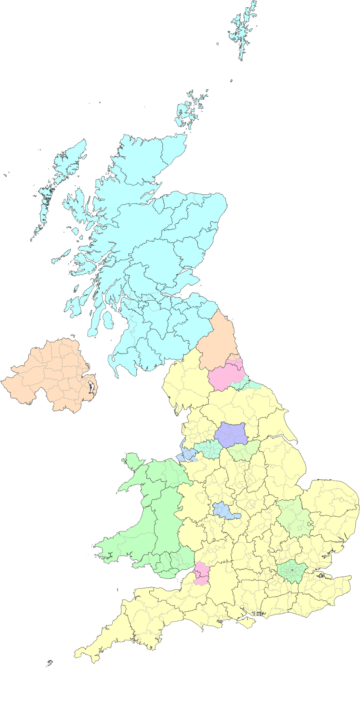
Despite removing these 10 combined authorities, some of which are large cities, what is left of England is still almost as big as all of the other states combined, which is unacceptable. We have also now introduced several even smaller entities - the state of England is now 41 times larger than Tees Valley.
Regions
For statistical purposes, the UK is divided into 12 "Regions" that currently have no distinct governmental powers. Many proposals of federalism in the UK have used these, so we can see what we would get if each of these were turned into a state:
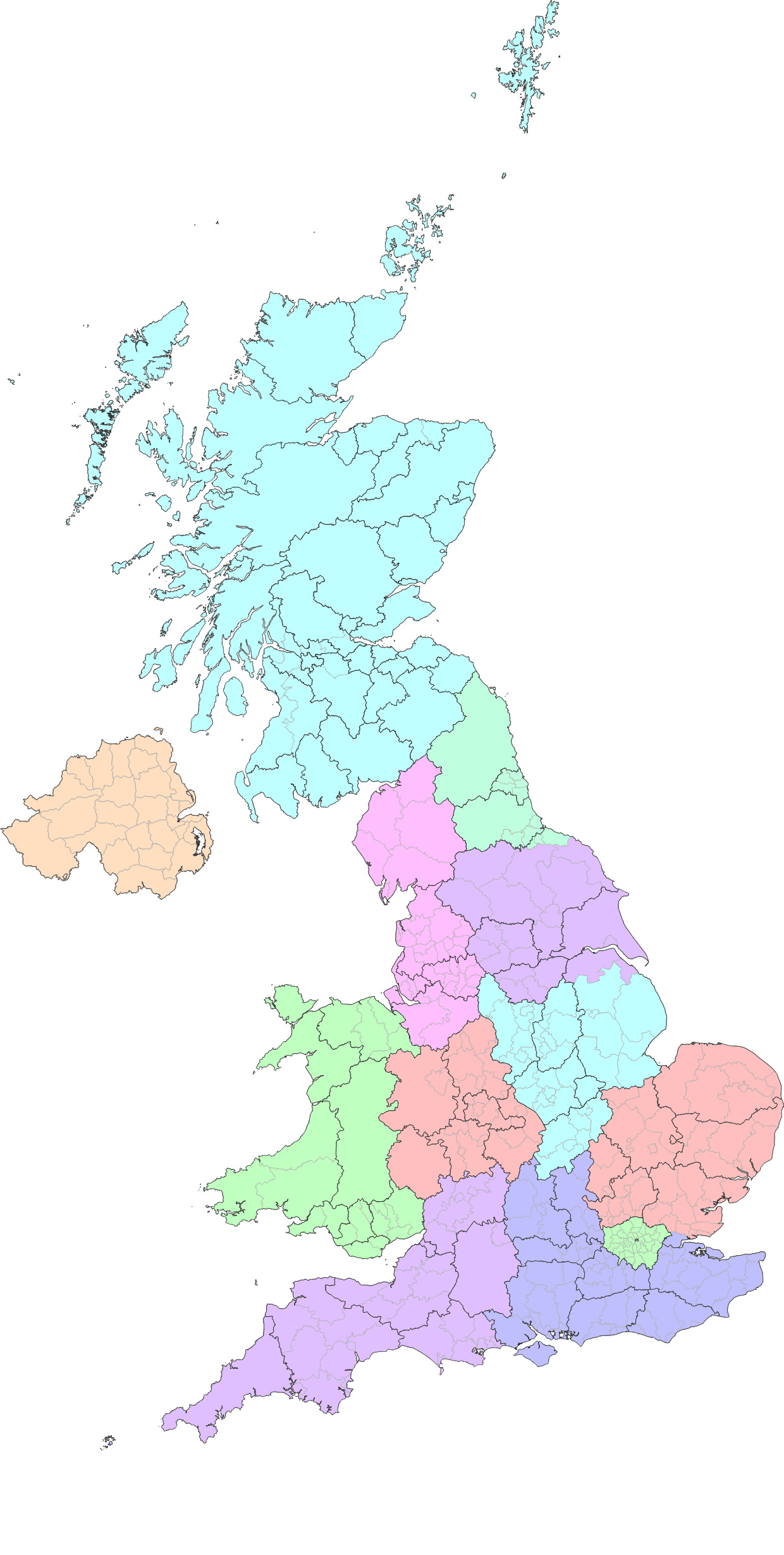
These are relatively evenly sized - the South East has around 5 times the population of Northern Ireland, which is acceptable. These divisions have been around for a while though, and they have not taken off as actual administrative regions for a reason. Most of them contain a mixture of cities and rural areas that do not naturally work together.
Regions & Combined Authorities
If we now split the combined authorities from the regions, we generate 21 states:
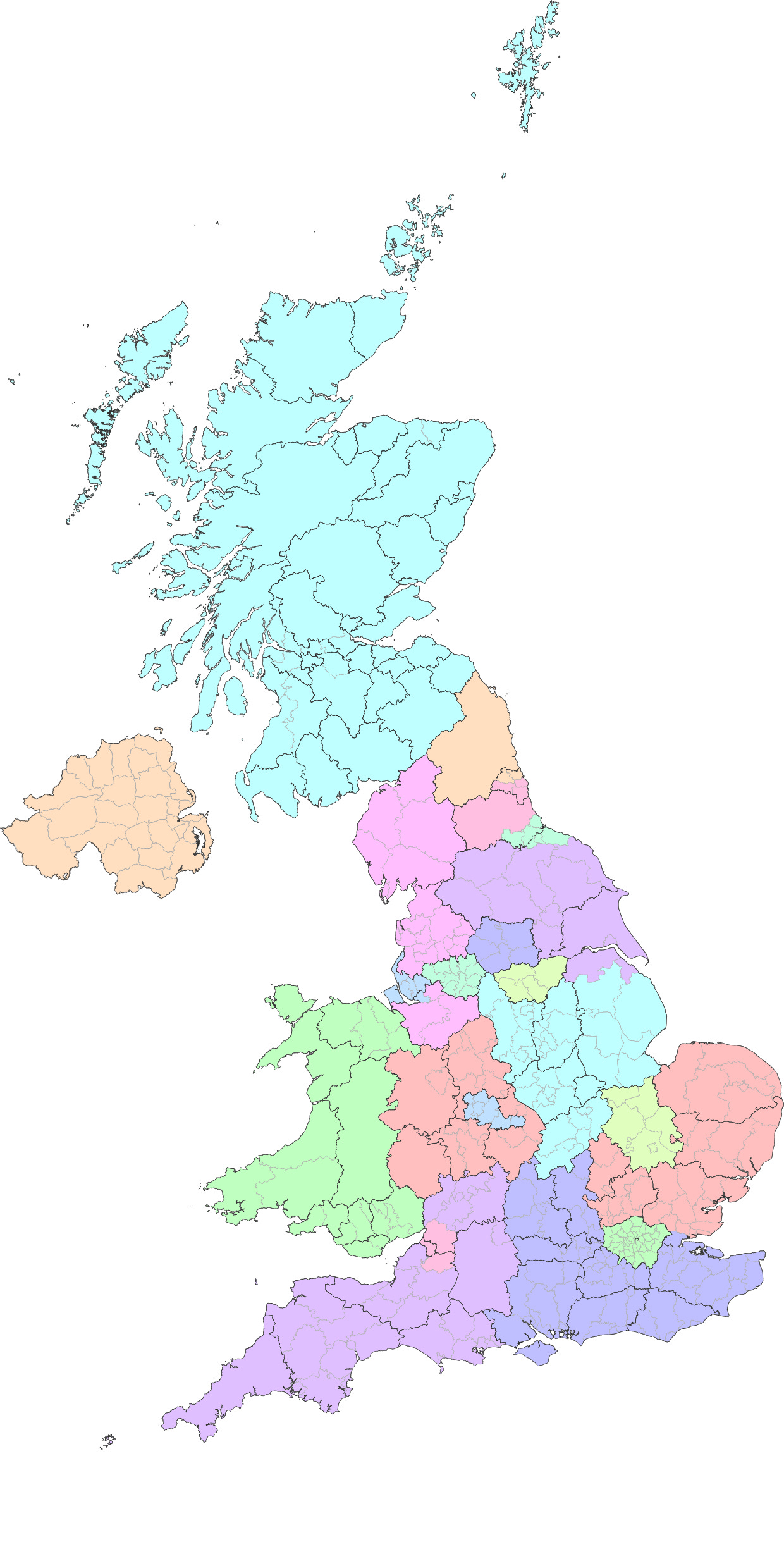
Splitting out the large cities in this manner makes the divisions far more likely to be functional - their respective governments will be able to focus their attentions on the relevant rural or urban issues respectively. Unfortunately however, the South East now has over 12 times the population of Tees Valley. As can be seen from the map, there is also an aesthetic issue - some of the regions have holes in them. This is not necessarily an issue, but it does make them look quite untidy which could make them unpopular, and be a barrier to implementation.
This is a good start though - from this basis, we can design states for the UK. We want them to be comfortably within the size limits, moderately consistent in character (urban or rural) and reasonably natural feeling, respecting local identities.
Going Further
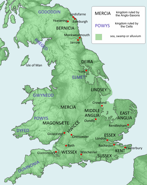
We can make adjustments to these 21 states to improve the proposal dramatically. For ease of reference, I will also suggest appropriate names for the proposed states that are a little less unwieldy. Most will be based on ancient kingdoms that occupied similar areas during the Heptarchy:
Kernow (Cornish for Cornwall)
Cornwall has a fairly independent streak, and although on its own it has quite a small population, Cornwall and Devon together are culturally similar and have a combined population of 1,750,000 which can be split from the rest of the South West.
Wessex (after the ancient Saxon kingdom)
West of England (Bristol & Bath) has a significantly lower population density than the other city-regions, so it could be combined with the remainder of the South West to form a state with a population of 3,540,000.
Essex (after the ancient Saxon kingdom) and Surrey (after the county of Surrey)
The "Home Counties" bordering London are quite different in character to areas further away from the capital. Essex, Hertfordshire, Buckinghamshire, Berkshire, Surrey and Kent are all part of London's commuter belt, giving them their own particular concerns and interests different to other parts of the UK.
Due to their population density, all of these counties combined would make for a very populous state, so it would make sense for there to be two such states. The difference between the Western and Eastern home counties is probably greater than the difference from North to South, as Essex and Kent both have coastlines and significant industry, while the other counties further inland have a very service heavy economy and are some of the wealthiest areas of the UK outside London.
This suggests that the counties of Essex and Kent could form one state (Essex) with a population of 3,070,000. The remaining home counties could form another state (Surrey), though excluding the districts of West Berkshire, Aylesbury Vale and Milton Keynes which are still fairly distant from London. This would give the state of Surrey a population of 3,460,000.
Sussex (after the ancient Saxon kingdom)
With the home counties removed, the Southern parts of the South East (Hampshire, the Isle of Wight, East Sussex, West Sussex and West Berkshire) can form the state of Sussex with a population of 3,240,000.
Anglia (after the ancient Angle kingdom)
Cambridge and Peterborough is a little on the small side, but with the home counties removed from the East of England region, its remnants (excluding Bedfordshire, which we will use later) can be combined with Cambridge and Peterborough to form the state of Anglia with a population of 2,720,000.
London, Middlesex and Croydon
London is often split into Inner and Outer London for statutory and statistical purposes. Outer London is further divided by the river Thames, with areas to the north of the Thames being quite different in character from the south due to greater tube network coverage, greater population density and having required much greater reconstruction following the second world war. Inner London (as defined by the ONS for statistical purposes) has a population of 3,230,000 and should probably continue to be referred to as London. North Outer London (North London as defined by the Boundary Commission, excluding areas of Inner London) has a population of 3,150,000 and overlaps significantly with the old county of Middlesex. South Outer London has a population of 1,790,000 and the largest city it contains is Croydon. Splitting London into 3 parts should not stop them coordinating on large projects such as the Oyster network.
Bromwich (from Beorma)
Beorma is the root of Birmingham, West Bromwich and Bromsgrove. Bromwich therefore seems like an appropriate name for the state made from the combined authority of the West Midlands (Birmingham).
Mercia (after the ancient Angle kingdom)
The rest of the West Midlands has a large hole cut out of it for Bromwich, Splitting Shropshire and Staffordshire on the top from Herefordshire, Worcestershire and Warwickshire on the bottom. There are better things we can do with the bottom 3, so it makes sense to remove them from Mercia, but this leaves quite a small state. Cheshire in the North West is separated from the rest of the North West by Liverpool and Manchester, so this can be added to Mercia instead. The M1 forms a natural dividing line close to the border between Derbyshire and Nottinghamshire, so we can move Derbyshire from the East Midlands to Mercia as well, giving a population of 3,530,000.
Cymru (Welsh for Wales)
Herefordshire shares a border with Wales and is much more sparsely populated than any of the English counties that it borders (it is actually one of the least densely populated counties in England). In this respect it likely has more governmental requirements in common with Wales than with other counties in the midlands. In fact, the prevalence of farming in Herefordshire, along with significant Welsh cultural presence in the western parts of the county have led to previous proposals to shift the Welsh border to include Herefordshire. Following through with this would make a lot of sense and only increases the population of Cymru to 3,260,000.
Hwicce (after the ancient Saxon kingdom)
In between the states so far defined, we have a number of counties that we have not done anything with. Worcestershire, Warwickshire, Oxfordshire, Bedfordshire and the districts of Aylesbury Vale and Milton Keynes can be combined into a state in the centre of England. Adding Northamptonshire too, from the East Midlands brings its population to 3,700,000.
This English heartland sits on the border between the North and the South, and is sandwiched between London and Birmingham making it extremely well connected and an attractive hub for many logistics firms. This region also contains the majority of the so called "Brain Belt", including Oxford, Bicester, Milton Keynes and Bedford, which along with Warwick have an unusually high density of headquarters for international and high-tech firms.
Far from being a contrived amalgamation of disparate areas, this state is fairly internally consistent, and would be the third wealthiest state per capita after London and Surrey. The ancient kingdom of the Hwicce was made up in large parts from the Cotswolds, Worcestershire and Warwickshire, but there is evidence for its influence reaching as far east as Northamptonshire and Rutland, making it an apt namesake.
Lindsey (after the ancient Angle kingdom)
Having lost Derbyshire and Northamptonshire, the East Midlands can reclaim the unitary authorities of North Lincolnshire and North East Lincolnshire from their bizarre inclusion within Yorkshire and the Humber. This gives Lindsey a population of 3,060,000.
Elmet (after the ancient Celtic kingdom)
Sheffield would be a relatively small state. Although Sheffield and Leeds both have their own combined authorities, they are only 35 miles apart, and are effectively joined into a single metropolitan area by the cities of Barnsley and Wakefield. By combining West Yorkshire with the Sheffield City Region, we can create a larger metropolitan region covering much of South West Yorkshire with a population of 3,700,000.
Northumbria (after the ancient Angle kingdom)
North of Tyne only incorporates the northern half of the "Tyne and Wear Metropolitan County" (a fairly large conurbation including Sunderland), but it also includes Northumberland which is very rural. Combining the Tyne and Wear Metropolitan County with Tees Valley gives us a metropolitan region with a population of 1,830,000. This region is split in two by County Durham, but we can deal with this later. The remainder of the North East region plus Northumberland have a population of only 766,000 which could be combined with the remaining Yorkshire and the Humber region.
Deira (after the ancient Angle kingdom)
After losing North Lincolnshire, North East Lincolnshire and Leeds, the Yorkshire and the Humber region can absorb what is left of the North East region from above, giving a state that is very large geographically, but very rural, with a population of 2,350,000. This state would contain only two moderately sized cities (York and Hull), but would contain three large National Parks (North York Moors NP, Yorkshire Dales NP and Northumberland NP) and four Areas of Outstanding Natural Beauty (Northumberland Coast AONB, North Pennines AONB, Nidderdale AONB and Howardian Hills AONB).
Rheged (after the ancient Celtic kingdom), Merseyside and Manchester
With the North West already excluding Liverpool and Manchester, and having moved Cheshire into Mercia, it is left with a population of 1,710,000. Greater Manchester can be left unchanged and the city-region of Liverpool (Merseyside) can incorporate the fairly urban unitary authority of Warrington.
Glesga (Scots for Glasgow) and Scotland
Glasgow is a very large urban area within the largely rural Scotland. Splitting it into its own state would make governing much more straightforward, and would not stop Scottish and Glaswegian governments from working together on projects if they felt so inclined. Specifically, taking the combined councils of West Dunbartonshire, East Dunbartonshire, North Lanarkshire, Inverclyde, Renfrewshire, East Renfrewshire and Glasgow City as a separate state from the rest of Scotland would result in a metropolitan state of 1,550,000 people and a largely rural state of 3,750,000.
Ulaidh (Gaelic for Ulster)
As before, no changes need to be made to Northern Ireland. A more interesting name wouldn't hurt though.
Proposal Based on Existing District Borders
This gives us the following 23 states:
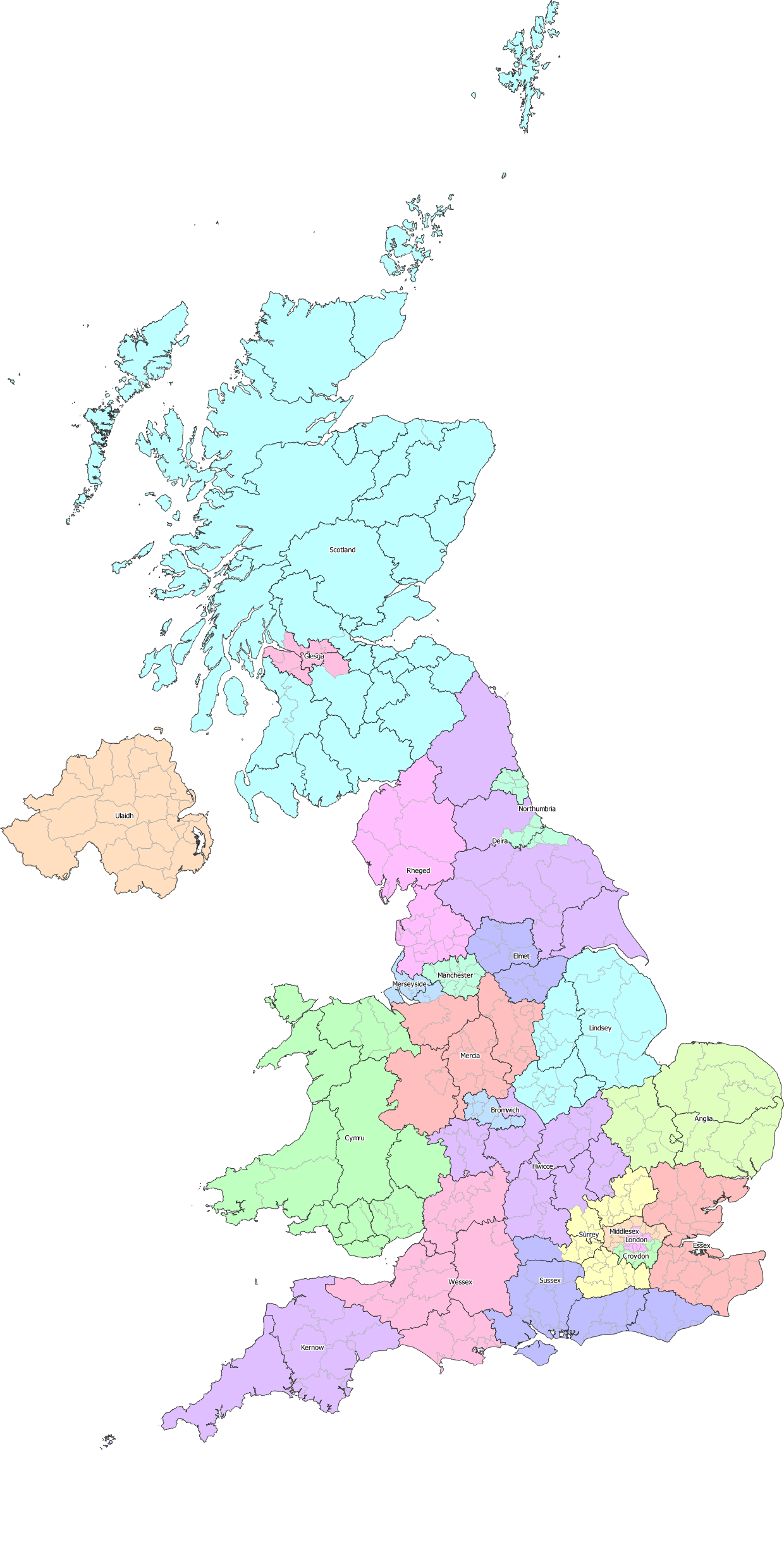
These 23 divisions would probably suffice - the largest (Scotland) is now less than 2.5 times the size of the smallest (Glesga), and they might generate more enthusiasm for becoming federal states due to having greater internal similarities than the current statistical regions.
The densely populated metropolitan states of London, Middlesex, Croydon, Bromwich, Manchester, Merseyside, Elmet, Northumbria and Glesga have autonomy to manage their affairs free from the demands of more rural constituents
The commuter belt states of Essex and Surrey can easily collaborate with the three states making up Greater London on issues such as transport links and the greenbelt.
The semi-rural states of Wessex, Hwicce, Sussex, Anglia, Mercia, Lindsey and Rheged have a lower population density than the commuter belt, but are still dotted with bustling towns and small cities.
The very rural states of Kernow, Cymru, Ulaidh, Deira and Scotland each have their own particular cultures and requirements, which make them cohesive states despite their remoteness.
Making Use of Existing Features
By relying on existing county and district borders, we have exhausted the low hanging fruit, but we can still do slightly better. There are a few more issues that it would be good to address, that will be possible if we allow ourselves to use roads, railways, rivers and National Parks/AONBs as borders as well.
The map below shows the National Parks, AONBs and National Scenic Areas (Scotland) overlaid upon the proposal based on district borders:
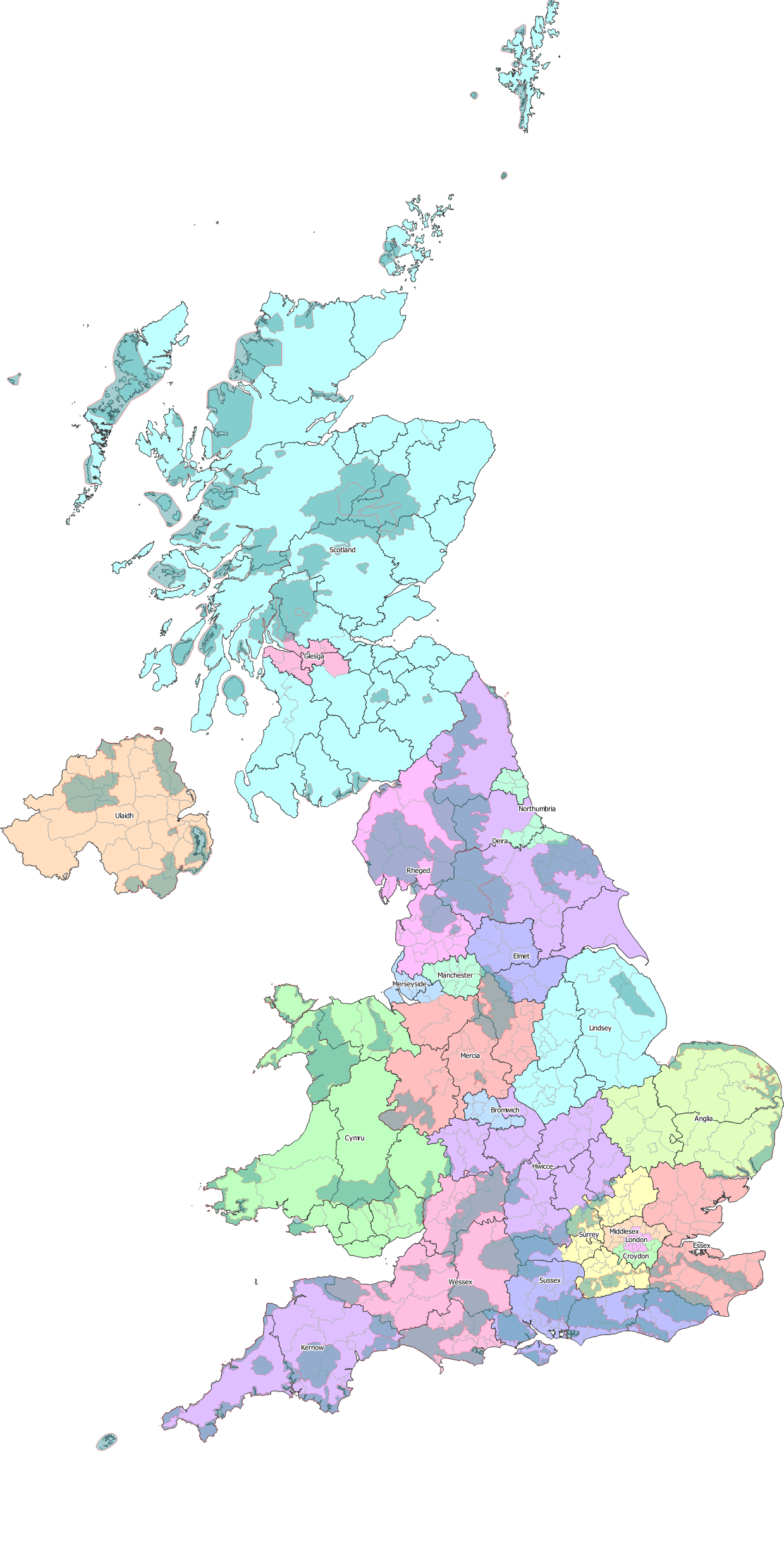
We can pick through the proposal above and make finer adjustments to try to resolve issues and make the states as cohesive as possible:
Northumbria is split into two by the very sparsely populated County Durham in Deira. Rather than moving the whole of County Durham into Northumbria, we can simply include the city of Durham itself, and anything East of it. This joins the two parts of Northumbria together whilst maintaining the high population density of a metropolitan state.
There are several large, very densely populated cities on the south coast (Bournemouth, Southampton, Portsmouth and Brighton) that are likely to have very different focuses from the surrounding rural counties that make up the rest of our state of Sussex. We can split these off, along with the Isle of Wight into a new metropolitan state. I will name this Solent after the strait of water between the South coast of England and the Isle of Wight. This is actually not a completely new idea, and a "Southern Powerhouse"/"Solent City" has been mooted before (though not without controversy).
The fringes of Glesga turn very quickly into very rural Scotland (West Dunbartonshire actually includes some of the Loch Lomond and the Trossachs National Park). Trimming some of this off, allowing the rural areas to be governed by Scotland would be sensible, whilst the densely populated North of South Lanarkshire (Rutherglen, Cambuslang, East Kilbride and Hamilton) are within the metropolitan area of Glasgow, so should be included.
The Western edges of the Yorkshire Dales National Park and the North Pennines AONB are in Rheged. By shifting the border between Deira and Rheged to the river Eden, this is avoided.
Kernow is significantly less densely populated than Wessex, but most of Exmoor National Park is in Somerset rather than Devon. National Parks and AONBs tend to have few residents, so it would be appropriate to move the rest of Exmoor NP, the Blackdown Hills AONB and all of the Quantock Hills AONB into Kernow.
With Herefordshire now being part of Cymru, the small sliver of Gloucestershire that is West of the river Severn is on the wrong side of a very natural border. Moving this area to Cymru removes another very sparsely populated area from Wessex. This area includes the Wye Valley AONB which currently straddles the border with Wales.
The counties of Essex and Kent are both quite large, extending a long way from London, which makes the Northern reaches of the county of Essex as well as High Weald AONB in Kent quite different in character from their more London focused parts. These areas could be ceded to Anglia and Sussex respectively, to better match their composition.
The North Wessex Downs AONB covers most of West Berkshire, but extends beyond it in most directions. Now that the densely populated Solent has been removed from Sussex, it is a much more rural state than the others surrounding it, making it sensible for the entirety of this AONB to be included within it. This being said, the name of the AONB might need to be changed, due to it being in the state of Sussex rather than Wessex. "The Berkshire Downs" would probably suffice. Notably, combined with the change above, Sussex now contains all of the North Wessex Downs AONB, the High Weald AONB and the South Downs National Park, which means that an even higher percentage of its land is covered by conservation areas than Deira.
Bromwich is surrounded by a few towns that might benefit from being served by the same government as the metropolis itself. Bromsgrove, Redditch, Nuneaton and Tamworth could all be considered commuter towns of the Birmingham conurbation. Also, by including Nuneaton we remove the hook that protrudes from the North of Hwicce.
Greater London is surrounded by the natural border of the M25, while the North and South circulars (the A406 and the A205) serve as a very natural border for inner London.
Other borders can be tidied up a little, following rivers, railways or roads where they are fairly close to the existing county border.
(As a side note, if we are using roads as borders, it is worth putting the border such that the road itself is clearly inside one or other of the states. If jurisdiction and responsibility over the road is not clear, it may not be maintained, and could be a source of conflict between the states. This is an implementation detail, and therefore not something represented in the maps below, but it is important to consider in any proposal changing border lines.)
This gives us the following map showing the starting point using existing county and district boundaries, the areas that are to change hands, coloured in various shades depending on which state they are going to be a part of, and the final proposal:
Final Proposal
Importing the data into Google Maps allows me to show a zoomable map of these states.
The final 24 states have the populations, areas and population densities as shown below, this time ordered by density:
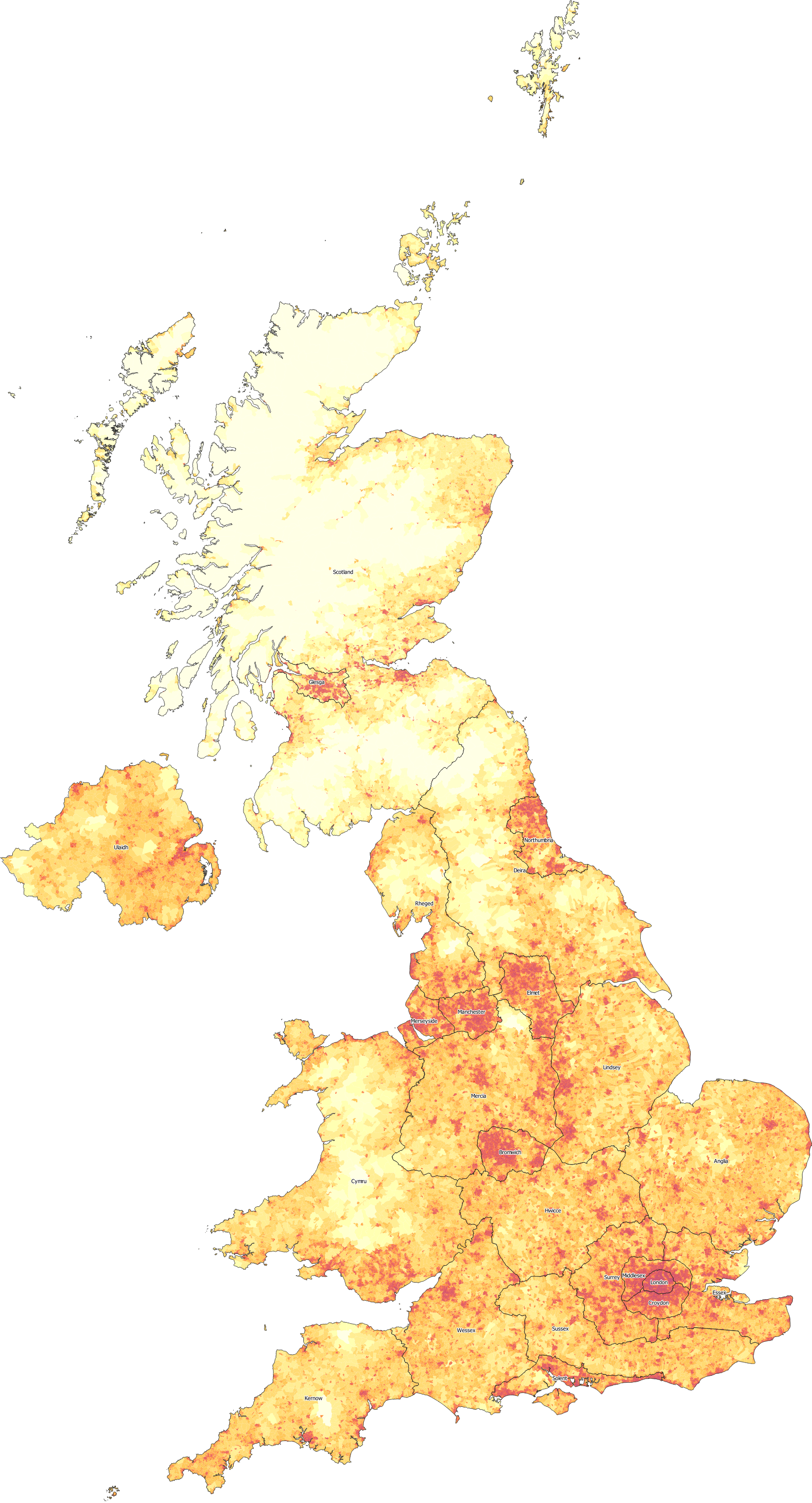
You can see that the largest state (still Scotland) now has just over twice the population of the smallest (Sussex), so there should be no California/Wyoming problems here. Half of the states (12) are varying degrees of rural, with population densities below 300 people per square kilometer. Around half the population (31 million people) live in these states, which gives a good balance between urban and rural.
The state of London has a population density more than three times that of the next most dense region, justifying it being its own state, as it is likely to have unique requirements even when compared with other metropolitan states. The other 9 metropolitan states have a population density over 1000 people per square kilometer - more than any US state, and higher than Harris County, Texas (Houston) or Los Angeles County, California. Finally, Surrey and Essex bridge the gap between metropolitan states and rural states, being a mixture of urban and rural in the commuter belt of Greater London.
You can see the population densities of the different states if we draw these proposed borders onto a map showing the population density of each census tract. In the map below, the yellow shaded areas have a population density below 10 people per square kilometer, the red shaded areas have over 1000 people per square kilometer, and the various degrees of orange are in between:
Is 24 too many states? After all, the "Regions" proposal only created 12. Personally, I don't think so - the smallest covers just over 1.6 million people - in between the sizes of the US states of Hawaii and Idaho, and almost 3 times the population of Wyoming. This is clearly a functional size, and this number of states allows them to have their own individual characters, without feeling like they are a random jumble of dissimilar areas. Many federal countries have a comparable number, or even more states than this:
It is also worth noting that by changing the borders away from the existing county and district borders, I have broken local government. It is generally accepted that local administrative units should be directly subordinate to states, and therefore should not cross state lines. There is therefore some work to do in adjusting the counties and unitary authorities that make up the UK to be compatible with this proposal. Don't worry - this post is already more than long enough, so all those maps can be saved until the next post.